
BOONE, N.C. — Linking earthquakes with the most likely causative fault just got better, thanks to an externally-funded project by Dr. Scott Marshall — professor of geophysics in the Appalachian State University Department of Geological and Environmental Sciences — and colleagues.
Working in collaboration with Harvard University, the California Institute of Technology (Caltech), and the Statewide California Earthquake Center (SCEC), Dr. Marshall and a team of researchers recently released and deployed a real-time digital tool that lets users know which fault has most likely caused any earthquake greater than magnitude three in southern California within a few minutes of the ground shaking.
The tool, a new and significant upgrade to the Community Fault Model (CFM) Earthquake-to-Fault Association Service, sends an automated email to registered users with links to a 3D view of the subsurface fault structure and the earthquake location, significantly increasing speed and clarity of scientific analysis and critical information flow.
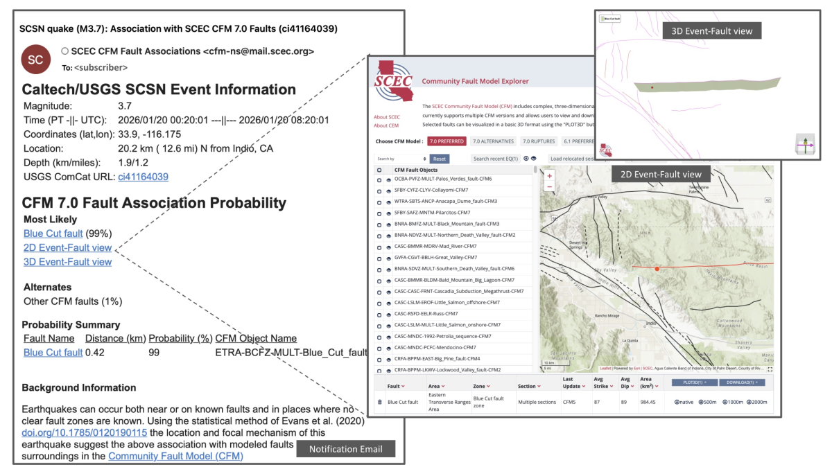
Example of the updated earthquake-to-fault notification email service which provides direct links to interactive 2D and 3D views of the regional faults and earthquake location. Image courtesy of SCEC
Marshall is a co-developer of the SCEC CFM, a 3D geometric representation of more than 400 active faults in California, where his roles have focused on data science tasks that include automating production of the model archive, ensuring self-consistency of the model components, visualizing the model, producing the model in several different file formats, and working with Caltech to deploy the new earthquake-to-fault association tool.
“The earthquake-to-fault association service provides near-real-time information about and interactive visualizations of the fault most likely associated with every earthquake in southern California larger than magnitude 3,” Marshall said. “This is valuable for scientists that need to speak with the media in rapid response scenarios, but also for planning and mitigating loss in the likely aftershock zones, as aftershocks can continue for hours to years after a large event. Knowing which fault is responsible for a damaging event can provide critical information to guide damage assessment teams.”
While the U.S. Geological Survey provides a sophisticated near-real-time earthquake notification service, it typically lacks information about what fault is likely associated with events, Marshall noted.
Learn more about the SCEC CFM here.
Interactively explore the CFM here.
###
About the Department of Geological and Environmental Sciences
Located in Western North Carolina, Appalachian State University provides the perfect setting to study geological and environmental sciences. The Department of Geological and Environmental Sciences provides students with a solid foundation on which to prepare for graduate school or build successful careers as scientists, consultants and secondary education teachers. The department offers six degree options in geology and two degree options in environmental science. Learn more at earth.appstate.edu.
By Bret Yager
February 27, 2026
BOONE, N.C.

Dr. Scott Marshall

Dr. Scott Marshall is a professor of geophysics in the Appalachian State University Department of Geological and Environmental Sciences. Photo by University Communications